It's Tuesday October 28, 2025![]() Dock Quote: “Anyone can slay...
Dock Quote: “Anyone can slay...

Hurricane Melissa Forecaster's Discussion & Computer Models
| ||||||||||||||
Hurricane Melissa Forecaster's Discussion # |
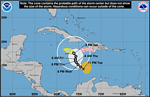
| A graphic showing several computer modeled projected tracks is at the bottom of this page. |
Hurricane Melissa Discussion Number 27 NWS National Hurricane Center Miami FL AL132025 1100 PM EDT Mon Oct 27 2025 Both Air Force and NOAA Hurricane Hunter aircraft have been investigating Melissa this evening. They found that the system is maintaining category 5 intensity with the central pressure near 903 mb and peak 700 mb flight-level and tail Doppler radar winds supporting 150 kt for the current intensity. The hurricane continues to exhibit a well-defined eye about 10 n mi in diameter embedded within extremely cold cloud tops to near -90 deg C. Upper-level outflow remains well defined over the system. Although such intense tropical cyclones typically undergo an eyewall replacement, radar observations from Jamaica do not show this occurring thus far. After remaining nearly stationary over the past few hours, Melissa now appears to be moving slowly north-northeastward with an initial motion estimate of around 020/02 kt. During the next few days, a mid-tropospheric trough is forecast to deepen near the southeastern U.S. coast. This should result in Melissa moving north-northeastward to northeastward with increasing forward speed through the forecast period. The official forecast is similar to the previous one and also close the tightly-clustered consensus and Google DeepMind guidance. The only significant difference in the track forecast compared to earlier today is a slower motion during the first couple of days, which delays the expected arrival of the core of Melissa over Jamaica, eastern Cuba, and the southeastern or Central Bahamas. Some fluctuations in intensity could still occur during the short period before Melissa reaches Jamaica. The primary influence on the hurricane's intensity during the next 36 hours will be the interaction with land. Some weakening is anticipated after the system moves over Jamaica and eastern Cuba. More substantial weakening is likely after the system moves past Cuba and over the southwestern Atlantic, where the vertical wind shear is likely to increase significantly. The official intensity forecast is close to the latest LGEM guidance. Key Messages: 1. Jamaica: Remain in your safe shelter. Catastrophic flash flooding and numerous landslides are expected through Tuesday. The eyewall’s destructive winds may cause total structural failure, particularly in higher elevations, leading to widespread infrastructural damage, prolonged power and communication outages, and isolated communities. Along the southern coast, life-threatening storm surge and damaging waves are anticipated through Tuesday. Failure to take immediate action may result in serious injury or significant loss of life. 2. Haiti and the Dominican Republic: Catastrophic flash flooding and landslides are expected across southwestern Haiti and southern portions of the Dominican Republic through midweek. In Haiti, extensive infrastructural damage and isolation of communities is likely. Tropical storm conditions are expected late Tuesday and Wednesday. 3. Eastern Cuba: Heavy rainfall with life-threatening flash flooding and landslides is expected to begin shortly. Life-threatening storm surge and damaging winds are expected late Tuesday and Tuesday night. Preparations should be rushed to completion. 4. Southeast and Central Bahamas and the Turks and Caicos: Hurricane conditions, life-threatening storm surge, and heavy rainfall are expected across portions of the southeast and central Bahamas on Wednesday. Residents should follow advice given by local officials and be sure to have preparations complete by Tuesday night. Tropical storm conditions, heavy rains, and a significant storm surge is expected in the Turks and Caicos Islands on Wednesday. FORECAST POSITIONS AND MAX WINDS INIT 28/0300Z 16.6N 78.5W 150 KT 175 MPH 12H 28/1200Z 17.5N 78.3W 150 KT 175 MPH 24H 29/0000Z 18.8N 77.4W 120 KT 140 MPH 36H 29/1200Z 20.7N 76.0W 90 KT 105 MPH...INLAND 48H 30/0000Z 23.0N 74.3W 85 KT 100 MPH...OVER WATER 60H 30/1200Z 25.8N 72.0W 80 KT 90 MPH 72H 31/0000Z 29.8N 68.2W 75 KT 85 MPH 96H 01/0000Z 38.9N 56.5W 60 KT 70 MPH 120H 02/0000Z 47.5N 40.0W 50 KT 60 MPH...POST-TROP/EXTRATROP $$ Forecaster Pasch |
The Forecaster's Discussion above often refers to several computer models. The graphic below includes multiple projected paths, showing what the different computer models indicate. The black line is the NHC (National Hurricane Center) path. This graphic is not an official NHC product. For the official NHC projected path of Hurricane Melissa click here.
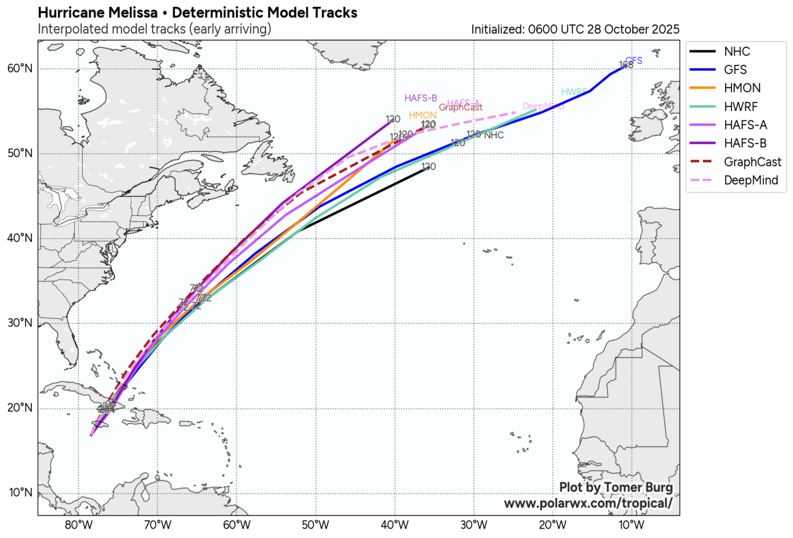
click image for a larger view
For more information about tropical storm computer models click here.